
Service to Resource Exploitation System Operators
Welcome to the Service to resource exploitation system operators service
Overview
In this service, near real-time information about geomagnetic disturbances which primarily affect directional drilling and aeromagnetic surveys, and ionospheric disturbances which primarily affect GNSS-based activities is unified. Resource exploitation activities that can be sensitive to space weather effects include offshore drilling and surveying activities. In more general terms, any resource exploitation activity depending on accurate recordings of Earth’s magnetic field and some position in the air or on the Earth surface will at times experience challenges related to space weather.
This service is implemented through a combination of products, tools and alerts which can be found in the following sections along with expert support provided by the teams constituting the SWE Network. Should you require further guidance in the use of this service, or have specific questions about any aspects of the service presented here, don’t hesitate to contact the Helpdesk.
Read more about this service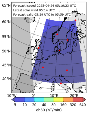
Highlights
Announcements
💡 Let us know what you think about our services in our Survey.
Products and Alerts
Products
Interplanetary medium at L1
Interplanetary Magnetic Field (IMF)
Solar Wind Bulk Velocity
- Near-Earth solar wind forecasts (WSA-Enlil + Ensemble)
- Empirical solar wind speed forecast
- Empirical solar wind speed forecast
- Solar wind speed forecast (STEREO-A persistence model)
- AWARE_NEXT Enhanced 24 hour solar wind forecast
- SWiFT
- Solar Wind Forecast Speed Comparison
- Near-Earth NRT solar wind (DSCOVR)
- SIDC Daily space weather bulletin archive
- SIDC Latest daily space weather bulletin
Solar Wind Bulk Density
Earth atmosphere and geomagnetic environment
Local External Magnetic Field on Ground
Local Geomagnetic Induced Geoelectric Field
- Maps for power and pipeline operators
- Table of modelled GIC
- Pipe-to-soil voltage (PSV)
- Horizontal electric field data (UK)
- Peak Geomagnetically Induced Current (GIC) for Scotland, England, Wales and the UK
- Average Geomagnetically Induced Current (GIC) for Scotland, England, Wales and the UK
- Peak Pipe-to-Soil Potential (PSP) for Scotland, England, Wales and the UK
- Average Pipe-to-Soil Potential (PSP) for Scotland, England, Wales and the UK
- 3-hourly Telluric index (Lerwick, Eskdalemuir, Hartland)
- GIC Index, Bgic for the UK
- Modelled surface electric field for UK and Ireland
Ionospheric, thermospheric and atmospheric conditions
Vertical Total Electron Content Map
- TEC map (Europe), current
- TEC map (Europe), forecast
- TEC map (Global), current
- TEC map (Global), forecast
- VTEC maps (Northern Europe)
- EIS Near real-time TEC maps for the European region
- IONMON TEC maps
- TEC nowcast modelled maps
- TEC nowcast modelled values at a given location
- Nowcasting of TEC over Italy
- Short Term Forecasting of TEC over Italy
3D Electron Density Grids
Tools
User Manual
Users of this service are resource exploitation companies and entities that are working with such companies or are generally performing mapping campaigns to search for natural resources. The products targeted toward the resource exploitation domain provides alerts and information on the local external magnetic field measured on ground and local geomagnetic induced geoelectric field. Some of the main products directed towards the resource exploitation companies are the following:
- For Spain and the surrounding area automatic e-mail warnings for geomagnetic storm occurrence – alerts when predictions exceed |50nT| in a Dst index forecast UAH-SWE Subscription by The University of Alcalá (UAH), and for geomagnetic storm recovery phase predictions.
- SIDC Latest human moderated alert, by the Royal Observatory of Belgium (ROB), provides alert texts triggered by a forecaster on duty.
- For UK the geomagnetic activity alert and the geoelectric hazard map, by The British Geological Survey (BGS).
- For UK Horizontal electric field data and horizontal magnetic rate of change, derived from the measurements of three magnetic observatories in UK, are provided by BGS
- For Sweden forecast of dB/dt, by the Swedish institute of Space Physics (IRF). Containing a map with forecast dB/dt values in nT/min.
- For North(West) Europe and Greenland, a collection of magnetogrammes (with data from several experts groups in G-ESC) covering North Europe and Greenland is provided by the Technical University of Denmark (DTU). This may also be filtered into different regions.
Interruptions
None

