GAFS
Geomagnetic Activity Forecast - a Service for Prospectors and Surveyors
(out of service since March 2007)
Service Status
The GAFS service ceased operation in March 2007.
Developer
Danish Meteorological Institute (DMI)
Geological Survey of Denmark and Greenland (GEUS)
Baker Hughes INTEQ Scandinavia
Technical Group
GIC & Ground Effects
SDA objective
Our objective is the development of a computer-based system for a targeted geomagnetic activity forecast service. It consists of a brief description of observed solar activity and current and expected geomagnetic activity together with a graphical scheme displaying the level of disturbance of the geomagnetic field expected over the next three hours, the next 12 hours and the next two days. The geomagnetic disturbance level is scaled according to the geographic area -- middle, high and polar cap latitudes -- and according to specific user requirements. The service will be provided automatically and continously. Automatically updated forecasts are presented in detail on a restricted Web site and a summary of expected activity levels on a publicly accessible web site.
Products
Two-day forecast of the level of geomagnetic activity in Denmark and
Greenland
Link to Project WebSite
http://www.dmi.dk/projects/ESA_SWAPP/Public/magoutlook.shtml
The service is not operational. If you are interested in this service or need further information please contact Jurgen Watermann
SDA description
Background
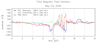 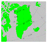
The geomagnetic field is at all times subject to temporal variations on a wide range of time scales. They originate in solar activity and variability of many different forms including solar flares, coronal mass ejections, solar wind sector boundaries and coronal hole streams. The figure above gives an example of geomagnetic variations of large amplitude observed during a major (but not extreme) geomagnetic storm at three sites located at the east and west coasts of Greenland, respectively (second figure above). The stations are neighbours in the sense that no other magnetometers were in operation in between them. The magnetic variations shown in the figure are uncorrelated. It is in therefore not possible to apply a-posteriori corrections for magnetic field variations to those measurements which were taken at a place somewhere in between these stations. Such conditions prohibit spatial interpolation between neighboring sites and render simultaneous measurements from remote reference stations useless.
Variations of such intensity can adversely affect any technical systems which rely on local magnetic field measurements to be taken in the absence of significant geomagnetic variations. Users who are unaware of and thus unprepared for the imminent occurrence of major magnetic field disturbances may conduct operations which later turn out to have been useless and eventually a waste of time and resources.
Our project attempts to address this problem by developing a service which gives advance notice of increasing geomagnetic activity and thus enables the affected users to plan and conduct their operations in a more cost-effective way. The project strives to address specifically the needs of
- oil companies which perform directional drilling controlled by magnetic field sensors
- magnetic survey enterprises which map magnetostatic anomalies for geological research and prospection
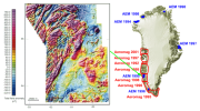  The figure to the left shows the result from an aeromagnetic survey conducted in 1998 in an area at the west coast of Greenland (see section indicated by an arrow). The local magnetostatic deviations from the geomagnetic reference field span about 1000 nT peak-to-peak. The spatial magnetic field variations in this example reach the same order of magnetic as the storm-time temporal variations displayed in the figure above. Under these conditions it is obviously not possible to conduct an aeromagnetic survey which can render useful measurements. Times during which magnetic storms are in progress have therefore to be avoided. The figure to the left shows the result from an aeromagnetic survey conducted in 1998 in an area at the west coast of Greenland (see section indicated by an arrow). The local magnetostatic deviations from the geomagnetic reference field span about 1000 nT peak-to-peak. The spatial magnetic field variations in this example reach the same order of magnetic as the storm-time temporal variations displayed in the figure above. Under these conditions it is obviously not possible to conduct an aeromagnetic survey which can render useful measurements. Times during which magnetic storms are in progress have therefore to be avoided.
Initial Development 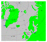 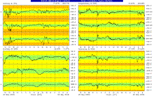 In order to aid these user groups to optimize their operations we have started to develop a scheme to forecast geomagnetic activity. As a first step we have begun to collect real-time magnetometer data from our geomagnetic observatory in Brorfelde, Denmark (BFE) and from three sites on the west coast of Greenland, namely the Qaanaaq (THL) and Narsarsuaq (NAQ) geomagnetic observatories and the Sondrestrom Upper Atmosphere Research Facility (STF) near Kangerlussuaq, see sample display to the right with real-time station map to the far right. These locations are of particular interest to our collaborators since Baker Hughes INTEQ provides survey management to oil companies operating in the North Sea, and GEUS supervises areomagnetic surveys conducted mostly along the Greenlandic west coast.
Methodology
The magnetic activity over the next three hours can be predicted (with limited confidence) from real-time solar wind data (obtained from the ACE and SOHO spacecraft) and geomagnetic activity parameters using neural network schemes ("L1 neural network"). A geomagnetic activity forecast over longer time spans must take into account observations of transient solar events such as coronal mass ejections and solar flares which affect geospace 2-4 days after initiation (in case they are earth-directed), depending on the velocity of the solar wind. A days-ahead prediction must further incorporate recurring phenomena including equatorial coronal holes and interplanetary sector boundaries.
We treat bursty, transient events and large-scale, recurring phenomena differently. We intend to use cluster analysis techniques and neural network classifiers to categorize solar transient events and select appropriate prediction algorithms. The most accurate predictions are expected during periods when the sun is relatively quiet and varies only at large temporal and spatial scales. We can then use a model which describes the propagation and development of the solar wind from the sun to the magnetospheric bow shock. Two classes of models can be considered, namely physics based models and statistical (or parameterized) models, among the latter one which is based on neural network techniques ("solar coronal neural network"). Hybrids between the two classes are also possible. The algorithm we intend to use starts from applying existing solar wind models, with the challenge to improve their predictive accuracy. Solar wind models build on quantitative knowledge (or assumption) about the distribution of the magnetic field over the solar surface. This requires real-time solar and coronal observations including solar magnetograms. We then use a scheme similar to that employed for the three-hour forecast to assess the propagation from the bow-shock to the ionosphere.
The primary data sets which we use as input to our scheme can be organized into four categories:
- remote sensing of the sun and solar corona
data sources: SOHO spacecraft and ground-based solar observatories
- in-situ sensing of the solar wind and interplanetary magnetic field
data sources: ACE and SOHO spacecraft
- in-situ sensing of solar X-ray and energetic proton flux in the magnetosphere
data sources: GOES satellites
- in-situ sensing of the magnetic variations at ground level
data sources: DMI ground-based magnetometers
Project Scheme
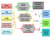 The flow diagram outlines the structure and the elements of the prediction scheme. The left hand column lists the input data sources, the central blocks summarize the elements of the prediction algorithm which are currently under development by the service provider (DMI), and the blocks on the right hand side show the expected output product designed for the service users (GEUS and Baker Hughes INTEQ). The flow diagram outlines the structure and the elements of the prediction scheme. The left hand column lists the input data sources, the central blocks summarize the elements of the prediction algorithm which are currently under development by the service provider (DMI), and the blocks on the right hand side show the expected output product designed for the service users (GEUS and Baker Hughes INTEQ).
The project will include a statistical analysis of prediction versus observation and an assessment of the costs potentially being saved through the use of a reliable geomagnetic activity forecast service. Summaries of the forecast and the performance evaluation will be made available on a publicly accessible web site.
Contact / Manager
Jurgen Watermann
|
;)
;)
;)
;)
;)
;)