| GSP Study Archive |
|---|
| Space Weather Studies |
| Applications Pilot Project |
| Feasibility Studies |
| CDF Space Weather Study |
| Past Workshops |
| Past Publications |
Scintillation quickmaps
Quickmaps and History of the Effects of Ionospheric Scintillations on GPS/GLONASS Signals
Developer
CLS
Technical Group
Ionospheric Effects & Activity Forecast
SDA objective
The core of the service is a routine daily and hourly acquisition and processing of GPS observations from a permanent network of about 250 receivers all over the world. The service prototype will present opposite the geographical distribution of the related sites and some animated maps of preliminary ionospheric scintillation occurrence indicators.
Products
The main outputs are:
- maps (animated gifs) of the scintillations effects available on the web,
- files of identified scintillations location/intensity (at subionospheric point of a receiver-satellite link)
Link to Project WebSite
SDA description
Any radio electric signal that propagates across the ionosphere (50-1000 km) may be severely perturbed by the ionization phenomenon and strong irregularities of electron concentration. The GPS space-based navigation service is the most largely spread human activity affected by what are called "the ionospheric scintillations". They cause on the signal a power attenuation, a noise augmentation on the phase and finally navigation errors. In the worst case, several hours of signal lockouts may occur along the geomagnetic equator. Low frequency HF communications also suffer from the ionospheric scintillations. Examples are e-mail and telephone with transmitter onboard aircrafts.
The objective of this project in the scope of ESA Space Weather Pilot Experiment is to furnish a worldwide and near real time observation of the ionospheric scintillations via their effects on the permanent and global GPS/GLONASS ground station network. The GPS observations are processed to identify signal tracking drop-outs, to derive phase fluctuations or power attenuations and to estimate a scintillation level parameter. A dedicated data base is created. It also includes ancillary information: satellite of the constellation, ray elevation, type of receiver... Several outputs are generated such as global maps showing the last hour activity or the day and night activities. Statistics are plotted with histograms at each site versus time, satellite elevation... The Service is available via a web interface that is composed of a public part and a private part. The private service is relative to confidential data coming from a regional receiver network or receivers onboard an aircraft or a satellite.
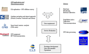
The partnership of this project includes all the actors needed to cover all the angles for the implementation of the service (Figure 1):
- users in the field of GPS applications and Telecommunications and of scientific applications,
- experts of GPS signal and observation processing for navigation or environmental by-products,
- scientists with a long standing expertise of the ionosphere,
- and a service developer and provider already involved in routine large-scale operations of space-based systems.
Figure 1
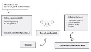
Figure 2 indicates the partnership organisation of the pre-operational service when a prototype is available at the end of 2003. During one year, the prototype is run in real conditions and refined. Experts contribute to its evaluations. Technical performances are evaluated in term of data access, products generation, web user interface availability... Scientific performances are also estimated thanks to external comparisons with other observation systems and models of the ionospheric scintillations distribution and dynamics. The relevance of the intensity level parameter definition to represent the strength of the scintillations is a key point and a specific effort will be focussed on it.
During 2004, a commercial service is defined and set up. Specific products with added-value are offered (alarms, regional monitoring, periodic statistics reports...). The service is promoted among the Space Weather community and the potential customers of the industry. Users evaluate the service and how it fits their needs. They estimate the quantitative benefits and the outlook for the future.
Figure 2
From 2005 up to 2007, the service is operated on a routine basis. Potential developments are investigated. They may be the processing of old GPS data at the maximum of solar cycle or during a major geomagnetic event. To test a ionospheric scintillation prediction model using the calculated 1 hour refreshed index as input for limit conditions already appears as of great importance for the market development. The method may also be applied to data of other nature than GPS: altimeters...
Glossary:
AIUB Astronomical Institute, University of Berne ENST Ecole Nationale Supérieure de Télécommunications DGAC Direction Générale de l’Aviation Civile LPCE Laboratoire de Physique et Chimie de l’Environnement CLS Collecte Localisation Satellites IGS International GPS service RBMC Brazilian Network for Continuous Monitoring of GPS GPS Global Positioning System
Contact / Manager
Jean-Jacques Valette
| Address: | Collecte Localisation Satellites Space Systems Metrology Department 8-10, rue Hermès, Parc Technologique du Canal 31526 Ramonville FRANCE |
| E-mail: | Jean-Jacques.Valette@cls.fr |
| Telephone: | +33 5 61 394 762 |